Back to LLPOA Water Monitoring Page
Download this report as a PDF file
Loon Lake Property Owners Association
Citizen Water Quality Monitoring
2009 Summary
Report
Prepared by
Jim Davies March 2, 2010
The Loon Lake Property Owner’s lake water monitoring program was again successful in this, our third year. Although another year of information gathered does permit general comparisons to the previous years, scientific methodology insists that many observations over several years must be made before definitive conclusions can be made about Loon Lake water quality trends. Spokane Community College is presently working on these three years of data to determine if some early signs of positively identifiable trends can be found. These findings should be available in the spring of 2010.
There is plenty of room for skepticism about the extent to which Loon Lake water quality is deteriorating, how long term or short term it may be, how much of it is man made, and what if anything we can or should do about it. Questionable data must be pinned down as accurately as we can, without undue delay, and promulgated widely. Why?, because there’s potentially large scale and long-term risk in doing either more or less than the facts warrant. Though there may be ample room for skepticism due to the short period of time (3 years) that we have been performing water quality analysis, it is much harder to be skeptical about whether deterioration has been occurring, to whatever extent and for whatever reason, over the last few decades. The data is clear. Loon Lake water quality has been and is deteriorating. This is not visible on the surface. Indeed it was not readily apparent until the data became available from the 2007, 2008 and 2009 water column study results. These results show that in the middle to late summer (and slowly getting earlier every year!) below 15 meters depth there is insufficient dissolved oxygen to sustain a healthy, deep/cold water Kokanee fishery. The data seems to validate recent fishery management studies for Washington Department of Fish and Wildlife which point to an anoxic hypolimnion limiting Loon Lake salmonid habitat (Scholz et al, 1988, McClellan et al, 2005). Skepticism, in the sense of questioning everything, is good. But to reap its benefits demands remaining open to listening to all the answers, not just the ones that support what we want to believe. We should look at all data with a critical eye and if some of the data used in an argument is flawed or insufficient in quantity or quality, we mustn’t fall into the trap of thinking that this proves or disproves anything.
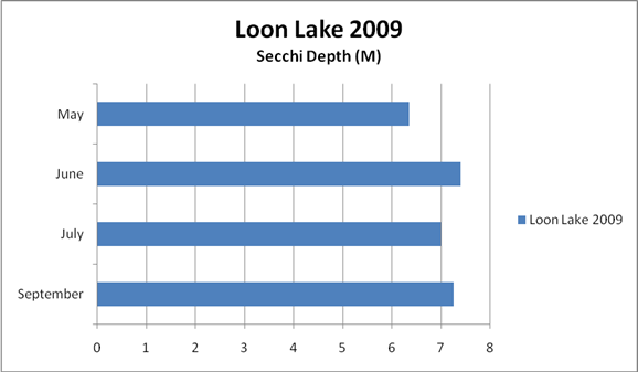
WATER CLARITY: The clarity of the lake is measured by submerging a Secchi disk until it disappears. In 1985 the Fisheries study conducted for the Department of Fish and Wildlife (WDFW) by EWU reported a summer average of 6.5 meters (21 feet). The 2007 Secchi disk measurements averaged very close to those 1985 averages, (6.1 meters - 20 feet). The 2008 measurements averaged 6.8 meters (22 feet). The 2009 measurements averaged 6.95 meters. Figure 1 below shows the 2009 measurements, No studies have yet been done to determine the possible causes of the 2008 and 2009 improvement in Secchi disk measurements. It is speculated that heavy snowfall during the winters of 2007/2008 and 2008/2009, which melted slowly through a late spring, allowed for a significant recharge of the aquifer and a subsequent influx of clean, cold water to the lake. This may have kept the water colder and cleaner through the early part of the summer.
Figure 1. Loon Lake Secchi disk clarity
Note: The lake is also measured from top to bottom for temperature, dissolved oxygen, pH and conductivity with the Hydrolab Data Sonde purchased in 2007 with a grant from the Department of Ecology. The instrument must be carefully calibrated before and after each use and carefully stored and cared for by LLPOA citizen volunteers that have been trained in its use.
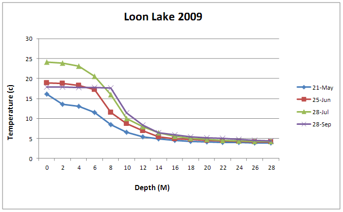
TEMPERATURE: The temperature measured over depth for each field trip is shown in Figure 2 and is consistent with past years of monitoring. It clearly shows the typical summer stratification of our deeper regional lakes. The measured profile shows an epilimnion (top warmer layer), the metalimnion (middle layer) where temperature drops relatively quickly with depth, and the hypolimnion (bottom layer), which is cold.
Figure 2. Loon Lake Water Column Temperature profiles
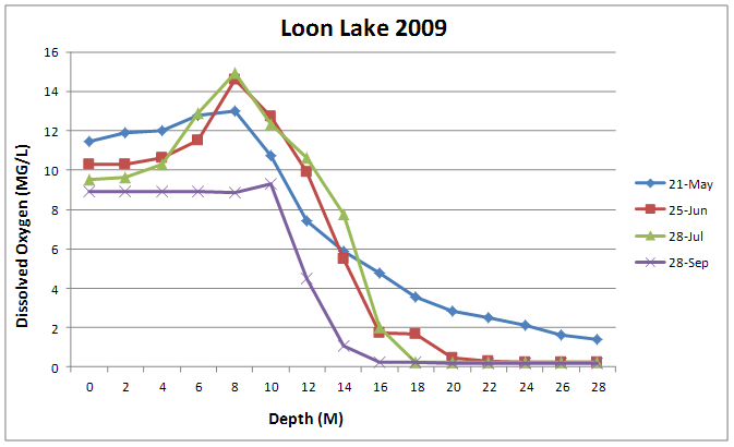
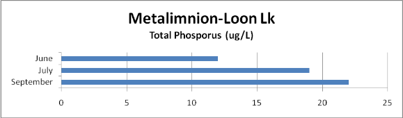
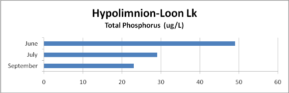
DISSOLVED OXYGEN: When the lake is thermally stratified, the bottom layer cannot mix with the upper layer and get reoxygenated. Decaying organic matter in the water, (dead algae and other aquatic plants and pollution), uses up oxygen in the process of decay and the oxygen is therefore depleted from the hypolimnion. Figure 3 shows that there is plenty of oxygen in the water column at the upper layers but later in the summer the dissolved oxygen goes to less than four milligrams per liter (mg/L) below approximately 15 meters. At this concentration of dissolved oxygen, fish cannot survive and phosphorus starts to be released from the sediments. The dissolved oxygen levels in Loon Lake are not good, but similar to those found in previous years. It is not yet possible to positively say if they are getting better or worse. Elevated phosphorus of the hypolimnion caused by depleted oxygen can be seen in Figure 4. This phosphorus gets remixed into the lake during the fall and contributes to next year’s algae growth. This self-perpetuating cycle of internal phosphorus loading continues to get worse if pollution is not controlled. Loon Lake Sewer District #4 was formed to stop septic system phosphorus from getting into the lake and has done a lot to slow the process. However it is very important that other sources of phosphorus are stopped. These sources include; storm water from hardscape (roofs, driveways, roads, etc.); fertilizer from landscaping; remaining large on site septic systems with drain fields (Granite Point Park) and small scale septic systems (the east side of the lake from Granite Point south). It is also important to provide shoreline vegetative buffers and maintain wetlands adjacent to the lake in order to absorb nutrients (most importantly phosphorus) as they migrate toward the lake. All new development within the Loon Lake drainage system (The Loon Lake Watershed) should be regulated in such a way so as to retain wetlands in their natural state, minimize or prevent runoff, prevent contamination of the aquifer from sewage systems that do not export nutrients from the watershed as does Sewer District #4 and preserve uplands so that the aquifer may continue to be recharged by precipitation.
Figure 3. Loon Lake Dissolved Oxygen profiles 2009
NUTRIENTS:
On each field trip, water samples are taken at the epilimnion, metalimnion and hypolimnion to determine nutrient concentrations. These are carefully measured samples captured with a Kemmerer Bottle at weighted depths. They are immediately placed in cold storage until they are delivered to the Spokane Tribal Laboratories where they are analyzed
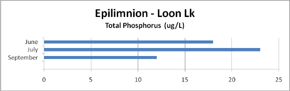
Figure 4. LOON LAKE TOTAL PHOSPHORUS BY STRATUM - 2009
Note: Be careful when viewing
the below chart in contrast with the two just above. The scale on this chart is from 0 to 60
rather than from 0 to 25 micrograms per Liter (μg/L\) as are the two
above.
Note: Detailed water column data is not appended to
this report. If you need this
information, contact J. Davies @ 509-233-2651.